Sinai Peninsula
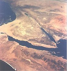

It lies between the Mediterranean Sea to the north, and the Red Sea to the south, and is the only part of Egyptian territory located in Asia as opposed to Africa, effectively serving as a land bridge between the two continents. In addition to its formal name, Egyptians also refer to it affectionately as the "Land of Fayrouz", based on the Ancient Egyptian "Dumafkat", which has the same meaning. The peninsula is currently controlled by Egypt, which has divided the region into two Egyptian governorates, and contains a population of approximately 1.3 million people.
The region has historically been the center of conflict between various political factions, based largely on its strategic geopolitical location. In addition to periods of direct rule by Egyptian governments (including the Ayyubids, the Mamluks, the Muhammad Ali Dynasty, and the modern Egyptian republic), like the rest of Egypt, it was also occupied and controlled by the Ottoman, and British empires. Israel invaded and occupied Sinai twice during the 20th Century, first during the Suez War of 1956, and secondly during and after the Six Day War of 1967. In the October War of 1973, it was the location of fierce fighting between Egyptian, and occupying Israeli forces.
History
Sinai was inhabited by the Monitu and was called Mafkat or Country of Turquoise. From the time of the First dynasty or before, the Egyptians mined turquoise in Sinai at two locations, now called by their Arabic names Wadi Maghareh and Serabit el-Khadim. The mines were worked intermittently and on a seasonal basis for thousands of years. Modern attempts to exploit the deposits have been unprofitable.These may be the first known mines.
The peninsula was governed as part of Egypt under the Mamluk Sultanate from 1260 until 1517, when the Ottoman Sultan, Selim the Grim, destroyed the Mamluks at the Battles of Marj Dabiq and al-Raydaniyya. From then until 1906, Sinai was administered by Ottoman provincial government of the Pashalik of Egypt, even following the establishment of the Muhammad Ali Dynasty's rule over the rest of Egypt in 1805. In 1906, the Ottoman Porte formally transferred administration of Sinai to the Egyptian Government, which essentially meant that it fell under the control of the United Kingdom, who had occupied and largely controlled Egypt since 1882.
The border imposed by the British runs in an almost straight line from Rafah on the Mediterranean shore to Taba on the Gulf of Aqaba. This line has served as the eastern border of Egypt ever since.
At the beginning of the 1948 Arab-Israeli War, Egyptian forces entered the former British Mandate of Palestine from Sinai to support Palestinian and other Arab forces against the newly declared State of Israel. For a period during the war, Israeli forces entered the north-eastern corner of Sinai. With the exception of the Palestinian Gaza Strip, which came under the administration of the All-Palestine Government, the western frontier of the former Mandate of Palestine became the Egyptian-Israeli frontier under the 1949 Armistice Agreement.
In 1956, Egypt nationalized the Suez Canal on the western side of the Sinai Peninsula and also used its control of the eastern side to impose a blockade on the Israeli port of Eilat. Following this, Israeli forces, aided by Britain, and France (which sought to reverse the nationalization and regain control over the Suez Canal), invaded Sinai and took control of much of the peninsula within a few days (see Suez Crisis). Several months later Israel withdrew its forces from Sinai, following strong pressure from the United States, and the Soviet Union. Following this the United Nations Emergency Force (UNEF) was stationed in Sinai to prevent any military occupation of the Sinai.
In 1967, Egypt reinforced its military presence in Sinai, renewed the blockade on Eilat, and on May 16 ordered the UNEF out of Sinai with immediate effect. Secretary-General U Thant eventually complied and ordered the withdrawal without Security Council authorization. Subsequent to Egyptian actions, Israel invaded Sinai, commencing the Six-Day War in which the Egyptian army was defeated, and Israel captured and occupied the entire peninsula. The Suez Canal, the east bank of which was now controlled by Israel, was closed.
In the October War of 1973, Egyptian engineering forces built pontoon bridges to cross the Suez Canal, and stormed the supposedly impregnable Bar-Lev Line while many Israeli soldiers were observing the holiday Yom Kippur. Though the Egyptians maintained control of most of the east bank of the Canal, in the later stages of the war, the Israeli military crossed the southern section of Canal, cutting off the Egyptian 3rd Army, and occupied a section of the west bank. After the war, as part of the subsequent Sinai Disengagement Agreements, Israel withdrew from the Canal, with Egypt's agreeing to permit passage of Israeli ships.
In 1979, Israel and Egypt signed a peace treaty in which Israel agreed to withdraw from the entirety of Sinai. Israel subsequently withdrew in several stages, ending in 1982. The Israeli pull-out involved dismantling almost all Israeli settlements, including the town of Yamit in north-eastern Sinai. The exception was Ofira, which became the resort town of Sharm el-Sheikh. The Treaty allows monitoring of the Sinai by the Multinational Force and Observers and limits the number of Egyptian military forces in the Peninsula.
Present
The Sinai Peninsula is currently divided among two Egyptian governorates, or provinces. The southern portion of the Sinai is called Ganub Sina in Arabic, literally "South of Sinai"; the northern portion is named Shamal Sina', or "North of Sinai". The other three governates converge on the Suez Canal, including el-Sewais, literally "the Suez"; on its southern end and crosses into African Egypt. In the center is el-Isma'ileyyah, and Port Said lies in the north with its capital at Port Said.Approximately 66,500 people live in Ganub Sina and 314,000 live in Shamal Sina'. Port Said itself has a population of roughly 500,000 people. Portions of the populations of el-Isma'ileyyah and el-Suweis live in Sinai, while the rest live on the western side of the Suez Canal in Egypt-proper. The combined population of these two governorates is roughly 1.3 million (only a part of that population live in the Sinai, while the rest live on the western side of the Suez Canal). Sinai is one of the coldest provinces in Egypt because of its high altitudes and mountainous topographies. Winter temperatures in some of Sinai's cities and towns reach −16°C.
Over the past 30 years the Sinai has become a tourist destination due to its natural setting, rich coral reefs, and biblical history. Large numbers of Egyptians from the Nile Valley and Delta have moved to the area to work in tourism, while at the same time development has robbed native Bedouin of their grazing land and fishing grounds. This clash of cultures has resulted in the Sinai becoming the site of several terrorist attacks targeting not only Westerners, and Israelis, but also Egyptians on holiday and working in tourism.
In order to help alleviate the problems faced by the Sinai Bedouin due to mass tourism, various NGOs have begun to operate in the region including the Makhad Trust, a UK charity who assist the Bedouin in developing a sustainable income whilst protecting Sinai's natural environment, heritage and culture.
http://en.wikipedia.org/wiki/Sinai


